
This Ever-Changing Map of a Made-Up Place Is Possibly Crazy, Definitely Beautiful
I love maps. Our walls are littered with them; even our shower curtain was a world map for awhile. And one of my favorite pastimes as a kid was dreaming up and then mapping imaginary countries, inspired by the fictitious atlases in books like The Phantom Tollbooth and The Hobbit.
So when my wife and I discovered “Jerry’s Map” at the American Folk Art Museum in New York City last month, I was giddy.
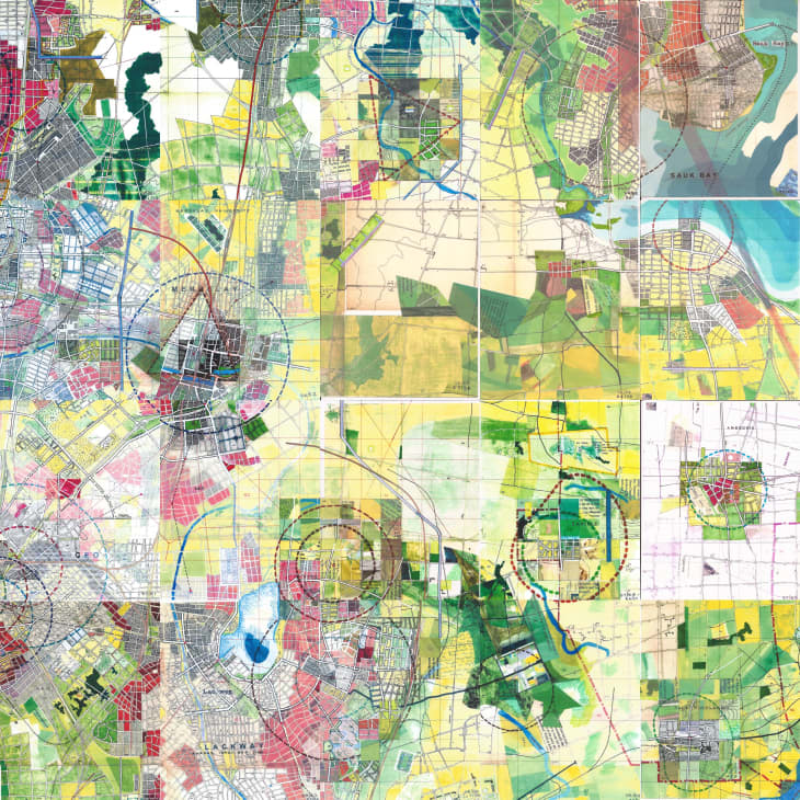
It’s a giant map of a fictional world, painted on thousands of 8″ x 10″ panels (a couple hundred of which are on display at the museum). The mix of recognizable cartographic details, vivid colors, and scraps of abstract collage — not to mention the sheer scope of the thing — is just captivating.
I got lost in the piece, peering in at minor details — a train station and converging tracks here, a cluster of houses there, a scrap of newsprint that’s meant to be a farm or a factory — and then stepping back to take in the swirling, abstract artfulness of the larger landscape.
The map began as a single doodle in 1963, when Michigan native Jerry Gretzinger started sketching a tapestry of streets, building plots, and rivers during downtime at a tedious job. “As a kid, someone had given us a whole stack of National Geographic maps,” Gratzinger has said. “I’d color them in, trace their rivers, read their faraway names. I was just fascinated by them—they conjured up all kinds of images in my mind.”
He later added a second page, then another — and from there, the map kept growing, to more than 3,200 panels that now take up over 2,000 square feet. Gretzinger kept at it in his spare time — during stints as an architect, Peace Corps volunteer, and handbag and fashion designer — until he set it aside in 1983. About 20 years later, his grandson found the project in the attic, and Gretzinger started up again in retirement.
That’s when things really got interesting: The imaginary region Gretzinger’s mapping — the main city is called Ukrania, but the mapped area extends far beyond that now — changes. It evolves. Each of those panels has actually been redrawn or repainted at least once, and the originals are archived. (He keeps careful “census” records; the mapped area is home to more than 17 million imaginary citizens.)
Gretzinger created a deck of cards with various instructions on them to guide the process — and to let him step back and play witness to his own creation. The cards, selected at random when he sets down to work, dictate whether an existing panel gets redrawn, and how: Perhaps there’s new development, a change in colors, or even a new “void” — in a sci-fi twist, the map is slowly becoming plagued by blank white spaces that devour anything in their path.
Of course, all of this is somewhat off-the-walls bonkers, if you think about it. It’s like an analog SimCity game that’s gotten way out of hand.
But for anyone intrigued by urban planning, or who’s studied the stories hidden in maps real or imagined, it’s a fascinating and, frankly, beautiful work of art.
The map has only been displayed in its entirety once, at the Massachusetts Museum of Contemporary Art in 2012. But a good-sized portion of “Jerry’s Map” is on display now through May 27th as part of the American Folk Art Museum’s “Vestiges and Verse” exhibition, which focuses on recently discovered self-taught artists. Admission is free, but a $10 donation is suggested (and worth it).